Beacon Looks to Build Out ‘Connected’ Bike Network Amid Trail Expansion
BEACON — The Hudson River town of Beacon wants to expand cycling, especially with the nearing completion of two nearby rail trails, but even supportive city officials aren’t sure how to pull it off.
Late last month, the city issued a call for consultants to identify gaps in Beacon’s bicycle network and recommend routes and infrastructure, but the request for proposals specifically lays out challenges in the town of 15,000 such as limited street space, demands for on-street parking, a frustrating traffic flow, an abundance of hills, and the potential for pedestrian conflicts.
The city hopes to connect existing bike routes and trails with a network of new paths, prioritizing routes according to likely use, proximity to schools, parks, libraries and transit, estimated costs, available funding and timing.
But the city’s approach comes as Beacon prepares for two major trail projects that could reshape how residents and visitors move through the city — and as advocates question how long it will take to translate planning into safer streets.
A plan built around the trails
Mayor Lee Kyriacou said the planned Beacon-Hopewell Rail Trail is a central reason the city is undertaking the bicycle plan now. The trail would follow the former Beacon rail line from Long Dock Park on the Hudson River northeast toward Fishkill, eventually connecting with the Empire State Trail in Hopewell Junction.
The railroad has received federal permission to remove the rail infrastructure as long as the corridor is preserved for future rail use, a process called “rail-banking.” Kyriacou said the city wants its bicycle network planned around the future trail before making other investments.
That outlook informed the mayor’s opposition to a proposal by the Beacon Bicycle Coalition to add bike lanes to Route 52 during its recent reconstruction. Kyriacou said the proposed lanes would have run close to the planned trail, potentially duplicating infrastructure and weakening the city’s case for funding. The reconstruction also had to move forward to avoid losing outside funding, he said, and engineers advised against including the lanes.
Kyriacou called the bicycle group’s push for Route 52 bike lanes “an error.” He said the group has since shifted toward supporting a bicycle plan that he urged the city to pursue two years ago.
The city’s request for proposals describes the rail trail as a potential backbone for Beacon’s bicycle network. The city completed a feasibility study of the Beacon-Hopewell corridor in late 2025, and engineering plans are expected around the end of 2026, according to the RFP. The city is still seeking funding for its section.
A second major trail project, the Hudson Highlands Fjord Trail, is planned to run south from the Beacon train station along the Hudson River toward Breakneck Ridge and other state park hiking trails. The project is designed, and its Breakneck Ridge section is already under construction. The Fjord Trail is expected to connect with the Beacon-Hopewell Rail Trail near Fishkill Creek, with the routes sharing part of the approach to the station.
Kyriacou said he would have preferred to obtain a grant for the bicycle study, but the City Council wanted the work completed sooner. He described the plan as a relatively modest expense and called it his “number one priority as mayor.”
Projects already moving
Beacon has already secured $3.6 million in federal funding for a Beekman Street reconfiguration, according to the city’s RFP. The project would connect the Metro-North station uphill to Route 9D, with a dedicated bike lane on the uphill side, sharrows on the downhill side, new sidewalks and lighting.
Beacon’s streets present different challenges for bicycle infrastructure. The RFP describes the urban core’s streets and sidewalks as generally narrow. Route 52, a major entrance to the city, was recently rebuilt, while Route 9D is another key north-south corridor. Both are state roads under the jurisdiction of the state Department of Transportation, meaning some potential changes would require state coordination.
One possible route identified in the RFP is North Cedar Street, which runs from Main Street toward Matteawan Road and the city’s middle and high schools. The city has considered turning North Cedar into a bicycle boulevard, a street designed to make cycling more comfortable without necessarily adding conventional bike lanes.
Main Street already has sharrows. According to the city’s RFP, the street was the first in Dutchess County to receive the markings, as noted in the county’s 2014 Walk Bike Dutchess plan.
The new study is intended to look beyond individual projects and assess how the pieces could work together. The consultant will review existing traffic-speed and traffic-volume data, bicycle counts, crash data, the city’s sidewalk inventory and existing trail studies and designs. The consultant will also be asked to recommend near-term projects that could compete for state or federal grants.
Advocates want action, not another study
Yvonne Caruthers, a co-founder of the Beacon Bicycle Coalition, welcomed the city’s decision to pursue a plan, but said concerns about cyclist safety have been discussed for at least 20 years through committees and reports without enough progress.
Caruthers wants specific recommendations for individual streets — and a process for ensuring those recommendations lead to action.
She pointed to Hoboken, N.J., as an example of a city that has pursued a comprehensive approach to street safety. Caruthers also wants bicycle planning to be coordinated with pedestrian improvements, rather than treated as a separate effort.
Beacon recently completed a sidewalk inventory that can help inform a future pedestrian plan. The inventory is not itself a full plan, and the city has been holding off on that larger effort while it seeks funding. The bicycle RFP directs the consultant to review the inventory and explain how the bike plan would fit into a broader pedestrian and bicycle plan.
Caruthers said the two issues overlap: streets that feel unsafe or difficult to navigate for cyclists can pose problems for people walking, too.
Main Street, bikes and business
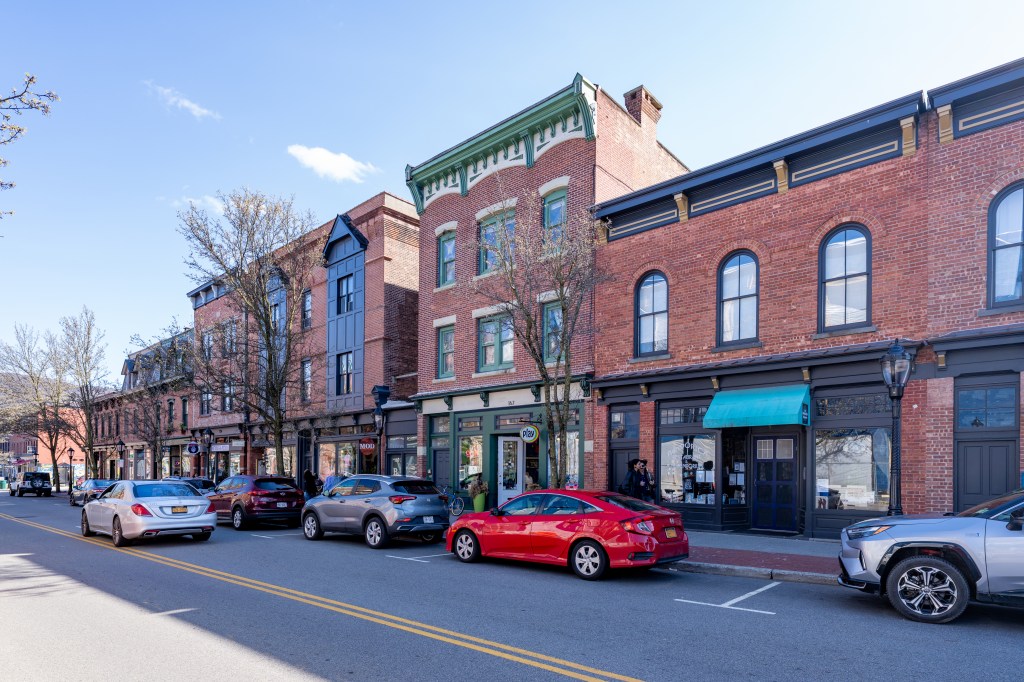
Main Street is the heart of Beacon’s business district, attracting visitors for shopping, dining and strolling, particularly on weekends. The question of how to accommodate bicycles in that busy commercial corridor is part of the larger debate over the city’s street space.
Amy Bandolik, manager of the Beacon Farmers Market, said cyclists tend to park on Elm Street rather than Main Street. She said bicyclists are a small share of market visitors compared to people arriving on foot or by car, though bikes become more visible on pleasant days.
Bandolik sees opportunities to encourage more people to bike to the market, including through coupons or a punch-card program. The Beacon Bicycle Coalition holds bicycle tune-up clinics four times a year and has included the farmers market on group rides.
The consultant will be expected to conduct multiple rounds of public outreach and coordinate with institutions including state DOT, Metro-North Railroad, Scenic Hudson and the Hudson Highlands Fjord Trail team. At a September City Council meeting, Kyriacou said bidders would need to explain how they planned to engage residents.
The RFP also asks the consultant to recommend education and enforcement measures and consider whether the city should adopt rules addressing e-bikes and e-scooters.
Connecting the network
Beacon, a city of roughly 15,000 people between the Hudson River and the Hudson Highlands, has a Metro-North station with express service to Grand Central Terminal. Interstate 84 runs just north of the city, and Route 9D and Route 52 serve as major approaches.
The proposed Beacon-Hopewell Rail Trail would link the train station, parks and Main Street before continuing north alongside Route 52 toward Fishkill and, eventually, the Empire State Trail. The Fjord Trail would extend south along the river, connecting the station with trails and destinations farther into the Hudson Highlands.
The bicycle plan is intended to examine how these trails can connect to city streets and one another, as well as to important destinations such as schools and transit stops. The RFP calls for a mapped, connected citywide network and recommendations on the type of bicycle facility best suited to each corridor.
Caruthers also pointed to Dutchess County’s recent passage of a three-foot safe-passing law. Approved by the County Legislature on Oct. 13, the measure requires drivers to leave at least three feet when passing cyclists, pedestrians and other vulnerable road users. If drivers cannot leave that much room, they must wait until they can pass safely. The law takes effect 90 days after it is filed with the state.
Proposals for the bicycle plan were due on Oct. 21. The city’s RFP says it intends to enter into a contract within 30 days of selecting a consultant. The consultant will then develop recommendations that city officials will need to weigh against costs, street constraints, funding opportunities and the needs of people who walk, bike and drive.
The mayor envisions a world where this plan creates new norms for moving around the city.
“Can you imagine being able to commute to the train station without touching the street,” Kyriacou said.

Read More:
Streetsblog has migrated to a new comment system. New commenters can register directly in the comments section of any article. Returning commenters: your previous comments and display name have been preserved, but you'll need to reclaim your account by clicking "Forgot your password?" on the sign-in form, entering your email, and following the verification link to set a new password — this is required because passwords could not be carried over during the migration. For questions, contact tips@streetsblog.org.